I've recently been reading GEOPHYSICAL RESEARCH LETTERS, VOL. 32, L10703, doi:10.1029/2004GL022266, 2005 Satellite-derived vertical dependence of tropical tropospheric temperature trends by Qiang Fu and Celeste M. Johanson (and PDF here) in an effort to understand the differences between S+C's (==UAH) vn5.2 and vn5.1 temperature series - see previous here.
The F+J paper looks good, and is well worth reading (thanks to SC I think for pointing it out).
The paper basically says (looking at the tropics) that the S+C vn5.1 is wrong, and indeed physically implausible. They say 'the near-zero trend from Spencer and Christy’s MSU channel-2 angular scanning retrieval for the tropical low-middle troposphere (T2LT) is inconsistent with tropical tropospheric warming derived from their MSU T2 and T4 data. We show that the T2LT trend bias can be largely attributed to the periods when the satellites had large local equator crossing time drifts that cause large changes in calibration target temperatures and large diurnal drifts'.
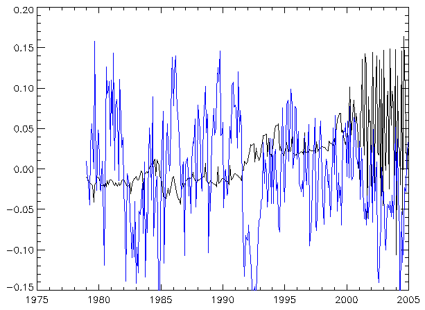
F+J identify a jump in about 1992/3 in the UAH-RSS series, differencing the TLT (RSS) and 2LT (UAH) series. This looks similar to what I found (pic here) between UAH vn5.1 and vn5.2. So that suggests that S+C have indeed revised their version towards the RSS version.
But why? S+C aren't saying, so we have to guess.
F+J identify problems with intersatellite calibration, in particular the LECT drift, and NOAA-11. LECT is "local equator crossing time" which ideally would be fixed but in fact changes. However, the jump I see in 1992/3 fits better with NOAA-12. F+J do say 'The two jumps over land near 1992 and 1995 seem to be related to satellite transitions, respectively, from NOAA 10 to 12, and from NOAA 11 to 14'. And the 1992/3 jump does seem to fit the introduction of NOAA-12 quite well (see fig 4 of Correcting the MSU Middle Tropospheric Temperature for Diurnal Drifts Carl A. Mears, Matthias C. Schabel, and Frank J. Wentz).
But looking at individual months doesn't make things obvious... the jump is not to a continuous new level, though there are hints that the first 3 months of 1992,3,4 are rather different... but the pattern breaks in 1995. What is true is that 5.2-5.1 diffs are very very zonal. Interestingly, this says (of NOAA 11) 'The primary mission sensor, the AVHRR, failed on September 13, 1994. The satellite was placed in standby mode in March of 1995 and was reactivated to provide sounding data after a NOAA-12 sounder failure in May 1997'.
Hmm, well, interesting bits and pieces but not a full story.
No comments:
Post a Comment